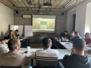
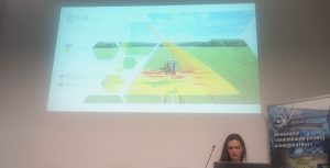
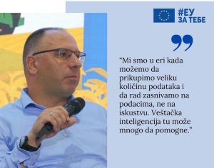
SATI – Newsletter February 2023
In order to achieve the project’s objectives, 4th newsletter was distributed electronically to the members of the SATI network and to all those who show
EXPLOREAssess how sustainable practices affect fields, farms, and incomeChange is never easy, particularly when abandoning tried-and-tested agricultural practices for new ones. Throughout the ‘explore’ stage,
SATI smartphone application provides a connection with the project website, the e-learning platform, the YouTube channel, and the Eurocontrol website (UAS no-fly areas).You can now
Open-Earth-Monitor is a EU-Horizon Europe funded project that aims at building an open-source cyber-infrastructure to accelerate uptake of environmental information and help build user communities
Soil Spectroscopy for the Global Good is a Coordinated Innovation Network funded by USDA NIFA Food and Agriculture Cyberinformatics Tools Program (Award #2020-67021-32467). This project
GILAB created the video in collaboration with EIEO, MKV Consulting, UPA, and SPIRITO. The Video will be used as promotional material and for training purposes
Our colleagues presented the AgriCaptureCO2 project in a science show, which is broadcast on a channel with a national frequency in Serbia – RTS2. For
The DIONE Workshop SMART agricultural monitoring within the CAP umbrella and beyond organized by InoSens doo and DIONE Consortium partners proved to be quite a success! More
The workshop is intended to show and promote the DIONE Toolbox – a ready-to-market and unique fusion of innovative technologies in the service of improved
Read our public deliverable D2.1 Stakeholder list, personas, and co-designed scenarios, one of the many available and upcoming DIONE scientific research papers! Whether you want
DIONE continues to inform its EO community about game-changing activities related to EU environment policies by providing an overview of the new Common Agricultural Policy
Super Resolution is the process of recovering a High Resolution (HR) image from a given Low Resolution (LR) image. An image may have a “lower
Farmer’s compliance monitoring tool is a Web GIS application which aims to be a decision support tool for Paying Agencies (Officials, Inspectors) and registered farmers/consultants.
Gilab in collaboration with OpenGeoHub, CVUT Prague, mundialis, Terrasigna, MultiOne has released Open Data Science Europe data portal on 1st of March 2021. It comprises terabytes of gridded data available as
How important is the role of the paying agencies for the development of the DIONE Environmental Performance tool? The paying agencies National Paying Agency of Lithuania(NPA) and Cyprus
Accounting a climate footprint is an established practice. However, accounting for C capture is largely based on manual methodologies that cannot be easily scaled. The
GILab team participated in the project – iSDAsoil, more precisely, GILab team developed a Web GIS solution that provides soil information for the African continent.
We are happy to announce that Gilab has become a part of this project. PARSEC has indirectly received funding from the European Union’s Horizon 2020
Last week We were one of four startup contestants who had an opportunity to present innovative solutions on which we are working. The meeting was
Geobiz project officially started with the kick-off meeting in Zagreb from 4th to 6th of February. Our aim, as partners, in this project is to
GEOBIZ is an Ersamus project aiming at: Establishing new and innovative forms of business-academic collaboration to support interaction in geoinformatics teaching / learning processes. Establishing
CropLab platform was successfully presented today at the Joint Research Centre by our CEO Dr. Milan Kilibarda.
Yesterday we had the honor to receive the visit of the Belarusian Minister for Science at our office in Belgrade Science Park. He was particularly
GILab now gives you the opportunity to try ALL CropLab platform services for free for one of your parcels, up to 30 hectares (this is
We are proud to announce the Ethiopia DIAD project kick-off. GILab, in collaboration with Wageningen University & Research (WUR) and GIZ Ethiopia, will develop a
GiLab is excited to announce it’s participation in H2020 DIONE project that will start in January 2020
GILab, in collaboration with Wageningen University & Research (WUR) and GIZ Ethiopia, will develop a web-based prototype for Design and Impact Assessment Dashboard (DIAD) for
DIONE, a H2020 project, proposes a close-to-market (TRL7) area-based direct payments monitoring toolbox that will address the forthcoming Modernised CAP regulation of using automated technologies
CropLab is an interactive and easy to use platform based on EO data that enables farmers and agronomists to access detailed information about critical indicators
GILAB was a partner in a consortium that has been awarded a contract by European Environment Agency (EEA) for an implementation of a project entitled “Copernicus Land
GILab team is proud to announce the first release of LandGIS. Web mapping client is available at https://landgis.opengeohub.org Information about LandGIS REST API is located at https://landgisapi.opengeohub.org Data store (metadata/layer preview and dowload) is available
Partnership agreements signed with Space4environment (coordinator of the consortium) to provision of services relating to the project “Copernicus Land monitoring services – Production of CORINE
SoilGrids is now online at https://soilgrids.org. There is also a 3D client based on CesiumJS, available at http://soilgrids.org/3d/ SoilGrids maps are developed and maintained by ISRIC – World
Demo app for crop monitoring support tool. It provides support to farmers by helping them monitor growth on their farms. In the background, this application
Technical solution and implementation plan for multipurpose Land Information and Monitoring Service for Montenegro. The proposed system should be based on a hyperresolution spatiotemporal land
GILAB team made web mapping client for “Soil property maps at 250 m” based on the AngularJS and OpenLayers, 3D client based on the CesiumJS. We made upgrade of REST SoilGrids
Technical solution and implementation of meteorogical measurements database system. Automatic integration of different data formats and sensors, storing and displaying them through istSOS service which employs OGC
Development of web/Android/iOS app realization of the SoilInfo app. The SoilInfo App is the mobile component of the Global Soil Information Facilities (GSIF). Its main
GILab team has developed LandGIS – Web GIS system that consists of (1) Web mapping client, which provides visualization of various spatio-temporal land-related datasets and enables querying per