How important is the role of the paying agencies for the development of the DIONE Environmental Performance tool?
The paying agencies National Paying Agency of Lithuania(NPA) and Cyprus Agricultural Payments Organization (CAPO) are responsible for the collection of data, regarding farmers’ declarations about areas, which are fully converted to organic farming, areas which are under conversion to organic farming and areas which are not converted to organic farming. The collected data and relative information provided by the agencies will be processed and used for the development of organic area-type maps in order to provide a deeper insight to each area’s soil properties. Furthermore, these data will be further exploited for the development of datasets, which will be exploited by an advanced deep learning models to identify organic/under conversion/nonorganic areas.
Finally, it is worth mentioning that the significance of their vital role lies on the fact that the collected information by both paying agencies as well as their experience on soil properties could be integrated for the development of accurate and reliable intelligent model. This model could be used by paying agency officials, farmers, agronomic consultants, and other stakeholders to study the soil properties of a farm or a greater area and monitor its evolution status through time.
Farmer’s Greening Compliance
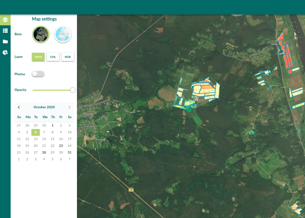
Team from GILab are developing an application for Farmer’s Greening Compliance. Through this application, farmers, inspectors, paying agency officials, agronomic consultants and other stakeholders will be able to check the compliance status of a farm. The compliance status will be evaluated at different points in time (each time new EO or field data is available) using the products delivered by other DIONE system components, through a unified Toolbox API which integrates these components together. The compliance engine will use the different available data together with the compliance rules for specific country to determine whether the farm is compliant or not (and why not). At the same time, the users will be able to see the farm’s parcels on a web map with different layers describing the biophysical conditions on the field through time (NDVI, Chl index, RGB). The users will also have the possibility to locally see the changes for a specific location on a graph. Application supports the display of geotagged photos collected by the user, as well as requests for new photos by inspectors. Read more