AgriCaptureCO2 services
EXPLOREAssess how sustainable practices affect fields, farms, and incomeChange is never easy, particularly when abandoning tried-and-tested agricultural practices for new ones. Throughout the ‘explore’ stage, we estimate the effects of various changes to yield, fuel and input costs, labour and farm income, and also the potential revenue from carbon credits.How we do it: Use of […]
Open-Earth-Monitor – A cyberinfrastructure to accelerate uptake of environmental information and help build user communities at European and global levels
Open-Earth-Monitor is a EU-Horizon Europe funded project that aims at building an open-source cyber-infrastructure to accelerate uptake of environmental information and help build user communities at European and global levels. It gathers a consortium of 23 organizations across Europe and beyond, starting on 1st of June 2022. The mission of the Open-Earth-Monitor project consortium is […]
Open Soil Spectral Library

Soil Spectroscopy for the Global Good is a Coordinated Innovation Network funded by USDA NIFA Food and Agriculture Cyberinformatics Tools Program (Award #2020-67021-32467). This project brings together soil scientists, spectroscopists, informaticians, data scientists and software engineers to overcome some of the current bottlenecks preventing wider and more efficient use of soil spectroscopy. It includes a […]
Erasmus+ SATI – GILAB created Dissemination Video
GILAB created the video in collaboration with EIEO, MKV Consulting, UPA, and SPIRITO. The Video will be used as promotional material and for training purposes as well. The video is available in English, Greek, Spanish, Turkish, and Serbian language. All versions of the SATI Dissemination Video are available on the SATI YouTube channel. For more […]
Geo-harmonizer – Gilab team has developed an application and services
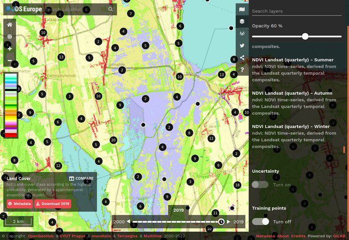
Gilab in collaboration with OpenGeoHub, CVUT Prague, mundialis, Terrasigna, MultiOne has released Open Data Science Europe data portal on 1st of March 2021. It comprises terabytes of gridded data available as Cloud-Optimized GeoTiffs and served via Geoserver. The project will collate, extend, harmonize, integrate, and distribute a wide range of freely available environmental and administrative data for Europe in the years […]
AgriCapture – Developing EO-powered services to promote soil carbon sequestration through regenerative agriculture
Accounting a climate footprint is an established practice. However, accounting for C capture is largely based on manual methodologies that cannot be easily scaled. The consortium has found a strong market need for a streamlined solution that can be scaled to meet the growing needs of C capture from Land Use, Land Use Change, and […]
iSDAsoil
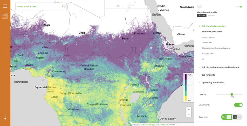
GILab team participated in the project – iSDAsoil, more precisely, GILab team developed a Web GIS solution that provides soil information for the African continent. The developed GIS solution consists of (1) Web mapping application, that enables visualization of multiple soil-related spatial data and querying specific locations for each dataset and (2) REST API that […]
GEOBIZ: Strengthening the capacity of academic institutions to better meet the needs of emerging geoinformatics industries in the Western Balkan countries and Moldavia
GEOBIZ is an Ersamus project aiming at: Establishing new and innovative forms of business-academic collaboration to support interaction in geoinformatics teaching / learning processes. Establishing a business academy platform that supports excellence in geoinformatics. Developing innovative teacher training programs and hands-on teaching / learning methodologies and content in technology-based geoinformatics courses, drawing on business-based needs […]
DIAD: Design & Impact Assessment Dashboard for Ethiopia

GILab, in collaboration with Wageningen University & Research (WUR) and GIZ Ethiopia, will develop a web-based prototype for Design and Impact Assessment Dashboard (DIAD) for Ethiopian landscape exploration and impact assessments via monitoring of site and landscape-level KPIs (physical, agronomic, socio-economic), based to the maximum extent possible on remote sensing and other remote data technologies.
DIONE: an integrated EO-based toolbox for modernising CAP area-based compliance checks and assessing respective environmental impact
DIONE, a H2020 project, proposes a close-to-market (TRL7) area-based direct payments monitoring toolbox that will address the forthcoming Modernised CAP regulation of using automated technologies to ensure more frequent, accurate and inexpensive compliance checks. Dione will: 1) apply the results of ESA’a SEN4CAP project that showcased the capability of Sentinel data to monitor the crop […]