Erasmus+ SATI – GILAB created Dissemination Video
GILAB created the video in collaboration with EIEO, MKV Consulting, UPA, and SPIRITO. The Video will be used as promotional material and for training purposes as well. The video is available in English, Greek, Spanish, Turkish, and Serbian language. All versions of the SATI Dissemination Video are available on the SATI YouTube channel. For more […]
AgriCaptureCO2 presented in a science show in Serbia
Our colleagues presented the AgriCaptureCO2 project in a science show, which is broadcast on a channel with a national frequency in Serbia – RTS2. For more information on the project, visit the AgriCaptureCO2 website.
Recap: SMART agricultural monitoring within the CAP umbrella and beyond!
The DIONE Workshop SMART agricultural monitoring within the CAP umbrella and beyond organized by InoSens doo and DIONE Consortium partners proved to be quite a success! More than 100 people had an opportunity to learn more about the DIONE Toolbox!More information on how it went: https://dione-project.eu/recap-smart-agricultural…/
DIONE Workshop SMART agricultural monitoring within the CAP umbrella and beyond
The workshop is intended to show and promote the DIONE Toolbox – a ready-to-market and unique fusion of innovative technologies in the service of improved agricultural monitoring – for Paying Agencies, Certification Bodies, Agricultural Consultants, Officials from Ministries to abide by the modernized CAP (Common Agricultural Policy) and other agri-related regulations as well as for […]
DIONE – D2.1 Stakeholder list, personas, and co-designed scenarios
Read our public deliverable D2.1 Stakeholder list, personas, and co-designed scenarios, one of the many available and upcoming DIONE scientific research papers! Whether you want to learn more about the new CAP structure after 2020, as well as how DIONE support tools conform to the foreseen post-2020 CAP regulations, or to gain a better insight […]
DIONE – The new CAP: fairer, greener, and more flexible
DIONE continues to inform its EO community about game-changing activities related to EU environment policies by providing an overview of the new Common Agricultural Policy (CAP)! The provisional political agreement reached on 25th June 2021 by the European Parliament and Council on the new Common Agricultural Policy introduces a fairer, greener, more animal friendly, and […]
DIONE – Super Resolution Modelling
Super Resolution is the process of recovering a High Resolution (HR) image from a given Low Resolution (LR) image. An image may have a “lower resolution” due to a smaller spatial resolution (i.e. size) or due to a result of degradation (such as blurring). Development of a super resolution model starts with the preparation of […]
DIONE – Farmer’s compliance monitoring tool
Farmer’s compliance monitoring tool is a Web GIS application which aims to be a decision support tool for Paying Agencies (Officials, Inspectors) and registered farmers/consultants. Main goal is to provide an automated rule-based and country-based compliance check. Apart from the main feature, this tool also aims to provide a whole variety of parcel-based and location-based […]
Geo-harmonizer – Gilab team has developed an application and services
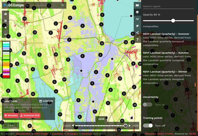
Gilab in collaboration with OpenGeoHub, CVUT Prague, mundialis, Terrasigna, MultiOne has released Open Data Science Europe data portal on 1st of March 2021. It comprises terabytes of gridded data available as Cloud-Optimized GeoTiffs and served via Geoserver. The project will collate, extend, harmonize, integrate, and distribute a wide range of freely available environmental and administrative data for Europe in the years […]
DIONE Toolbox
How important is the role of the paying agencies for the development of the DIONE Environmental Performance tool? The paying agencies National Paying Agency of Lithuania(NPA) and Cyprus Agricultural Payments Organization (CAPO) are responsible for the collection of data, regarding farmers’ declarations about areas, which are fully converted to organic farming, areas which are under conversion to organic farming […]